Aviary
Aviary is an air traffic scenario generation package developed as part of the BlueBird project. It aims to make available a large number of simple (but non-trivial) air traffic control scenarios suitable for the training of an artificial agent via reinforcement learning. The package also includes a set of evaluation metrics for measuring performance in the air traffic control challenge.
Each aviary scenario consists of two parts:
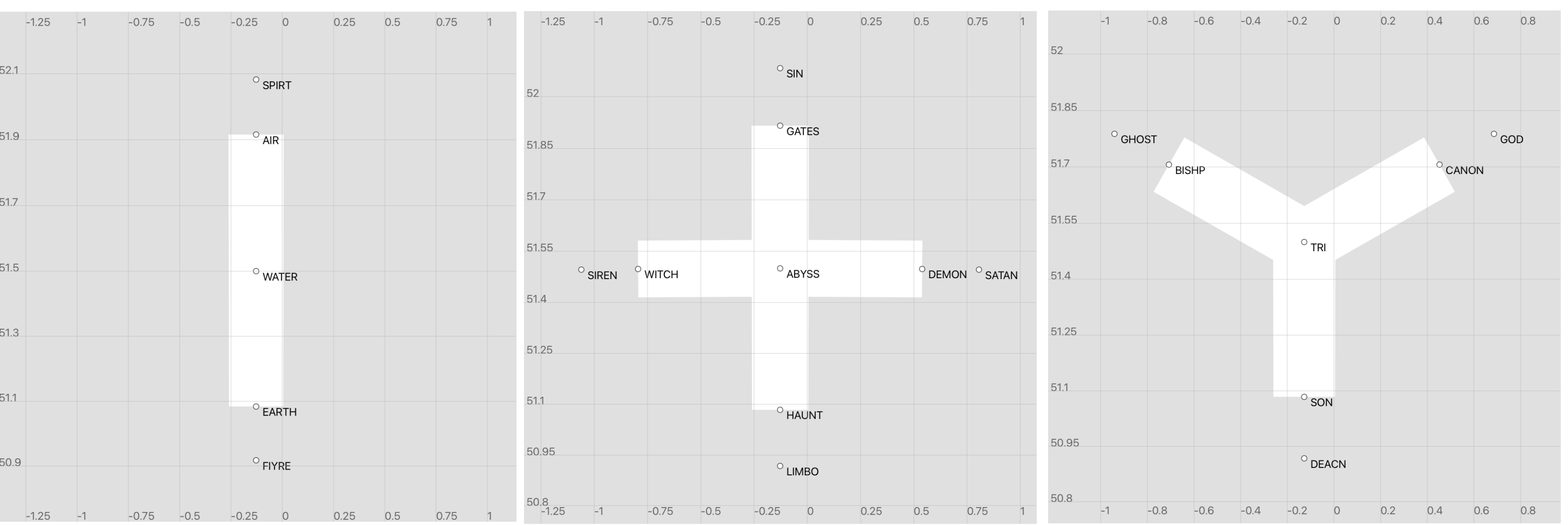
An airspace sector definition. Three elemental sector types are supported:
I sector, representing a linear airway
X sector, representing a pair of intersecting linear airways
Y sector, representing a pair of merging airways.
C sector, customised sectors and waypoints corresponding to real-world ATC sectors
Aviary scenarios take place in a sector of I, X, Y, or C type. In addition to defining the airspace boundary, a sector includes a set of fixed waypoints and a corresponding set of routes through the sector, where a route is defined as a sequence of fix points.
Sector definitions are serialised in GeoJSON format.
A sequence of aircraft whose routes pass through the sector. Each aircraft is defined by the following attributes:
   - callsign
   - aircraft type
   - initial position
   - arrival time relative to the scenario start time ("timedelta")
   - departure airport
   - destination airport
   - current flight level
   - cleared flight level
   - requested flight level
   - route (sequence of fix points crossing the sector)
Aircraft definitions are serialised in JSON format.
Installation
Install from the repository root directory:
pip install .
Developer install:
pip install -e .
Usage
Aviary supports:
Generation of I, X, Y, and C sector definitions in GeoJSON format
Generation of aircraft definitions in JSON format
Translation between aviary and BlueSky scenario formats
Sector generation
Run the sector_geojson.py script passing the following command line arguments:
sector_typeI, X or Ysector_nameAny stringoriginLongitude/latitude coordinates separated by a commalower_limitSector lower limit flight levelupper_limitSector upper limit flight levelfilename_prefixOutput filename prefix (optional)output_pathOutput file path (optional)
Example:
sector_geojson.py --sector_type=X --sector_name="X-sector" --origin=-0.1275,51.5 --lower_limit=140 --upper_limit=400

Scenario generation
To generate a simple overflier-climber scenario, run the overflier_climber.py script, passing the following command line arguments:
cruise_speedA CSV file containing aircraft cruise speed by aircraft type and flight levelcruise_speed_indexThe name of the index column in the cruise speed CSV fileclimb timeA CSV file containing cumulative aircraft climb time by aircraft type and flight levelclimb_time_indexThe name of the index column in the climb time CSV filedowntrack_distanceA CSV file containing aircraft downtrack distance by aircraft type and flight leveldowntrack_distance_indexThe name of the index column in the downtrack distance CSV filesector_typeI, X or Y (defaults to “I”)aircraft_typesA comma-separated list of aircraft types to appear in the scenarioflight_levelsA comma-separated list of flight levels to appear in the scenariothinking_timeA float, specifying the “thinking time” in seconds; this extends the scenario to make climbing ahead of the overflier a possibly optimal solutionseedA random seedfilename_prefixOutput filename prefix (optional)output_pathOutput file path (optional)
Note: to enable any user to generate overflier-climber scenarios, approximate CSV lookup tables for the aircraft cruise speed, climb time and downtrack distance are provided in the aviary/resources directory. Three aircraft types are included (A320, A343 and DH8D), each of which may be found in the BlueSky simulator’s OpenAP aircraft performance model. These tables contain simple approximations, obtained by linear (in the case of cruise speed) and cubic spline (in the case of climb time and downtrack distance) interpolation, and should not be supposed to accurately represent aircraft performance at all levels. In particular, the climb time and downtrack distance approximations for the A320 & A343 aircraft types are not accurate above FL ~300.
Example:
overflier_climber.py --cruise_speed=cruise_speed.csv --cruise_speed_index=FL --climb_time=climb_time.csv --climb_time_index=fl_bins --downtrack_distance=downtrack_distances.csv --downtrack_distance_index=fl_bins --sector_type=I --aircraft_types=DH8D,A320,A343 --flight_levels=300,360,400 --thinking_time=60 --seed=22
Scenario translation
BlueSky is an open source air traffic simulator. To convert an aviary scenario into the format expected by BlueSky, run the parse_scenario.py script passing the following command line arguments:
sector_geojson Full path to an aviary GeoJSON sector definition file
scenario_json Full path to an aviary JSON scenario file
output_pathOutput file path (optional)
Example:
parse-scenario.py --sector_geojson=I-sector.geojson --scenario_json=overflier-climber-22.json
